Author:
Afeez Azeez
Director, Photogrammetry and Remote Sensing / Mapping, Office of the Surveyor General of the Federation of Nigeria
For many fast-growing cities, decisions about infrastructure, land use, and resilience are still made with incomplete or outdated spatial information. In Nigeria, as in much of Africa, the pace of urban growth has outstripped the availability of modern, high-resolution mapping needed to plan confidently at street and parcel scale.
That gap matters. When data lacks precision, planners compensate with assumptions, engineers build conservatively, and risks—from flooding to informal development—are harder to anticipate. The result is not a lack of ambition, but a lack of visibility.
That is the context in which the Office of the Surveyor General of the Federation (OSGOF), in partnership with the PLACE Foundation, undertook a landmark drone surveying initiative in parts of Abuja. The project has delivered one of Africa’s first comprehensive ultra-high-resolution orthorectified imagery datasets designed specifically for very large-scale topographical mapping and the creation of a 3D digital twin of the city.
This is not mapping for display. It is mapping for decision-making.
Closing long-standing data gaps
Across many Nigerian cities, baseline geospatial data has often been limited by resolution, coverage, or age. Traditional satellite imagery rarely provides the detail required for modern urban management, while global street-level platforms cover only small portions of the country. These constraints have made it difficult to support precise land administration, proactive infrastructure planning, or advanced disaster preparedness.
The Abuja initiative was designed to change that equation by producing authoritative, government-owned data at a level of detail that matches the city’s needs today.
Mapping at speed and scale
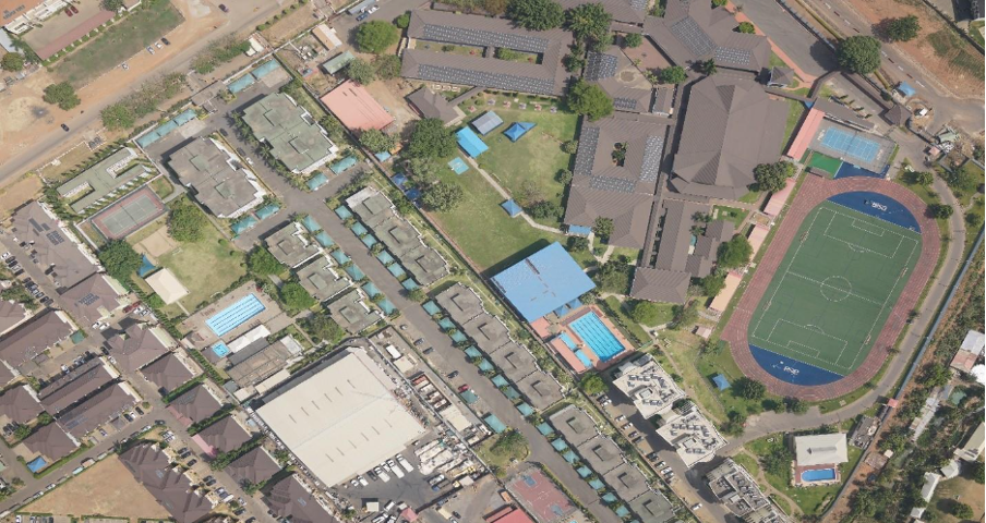
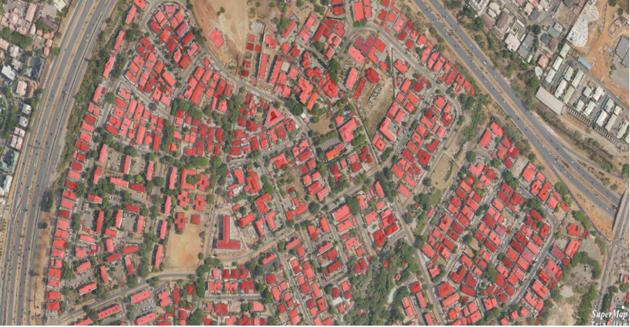
Over a ten-day period, the project deployed advanced unmanned aerial vehicles to capture data across approximately 150 square kilometers of the Federal Capital Territory—demonstrating that ultra-high-resolution mapping can be delivered rapidly, not over years.
The data was captured at a ground sample distance of 5–10 centimeters, an order of magnitude more detailed than standard commercial satellite imagery. Aerial operations used Trinity mapping drones, complemented by ground-level data collected with Mosaic 51 mobile mapping systems producing 12.3K resolution 360-degree street imagery. Differential GPS was used throughout to achieve survey-grade, centimeter-level accuracy, ensuring the data is suitable for demanding engineering, planning, and legal applications.
Together, these elements form a coherent, high-fidelity spatial foundation rather than a patchwork of disconnected datasets.
From imagery to usable intelligence
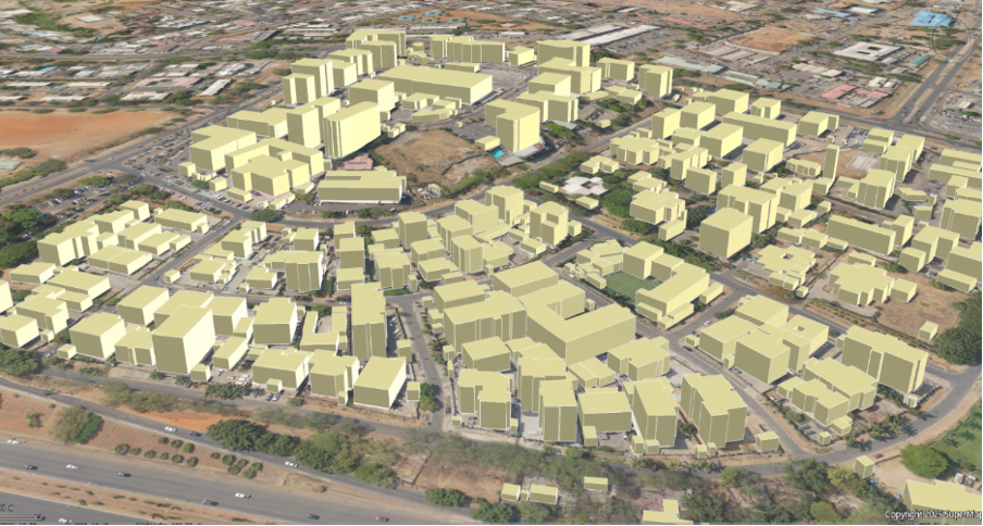
Raw imagery alone does not solve urban challenges. The real value of the initiative lies in how that data was transformed into actionable products: geometrically corrected orthophotos for precise measurement; digital surface and terrain models to support flood and slope analysis; highly detailed 1:1000 topographic maps showing buildings, roads, and contours; and a 3D digital twin that enables simulation and “what-if” analysis.
These outputs support concrete use cases. Urban planners can identify and monitor informal settlements with far greater accuracy. Emergency managers can train and plan using realistic flood and response scenarios. Climate analysts can assess urban heat islands and identify opportunities for green infrastructure. Asset managers gain a reliable inventory of roads, streetlights, and utilities to support maintenance and investment planning.
In each case, the shift is from reactive decision-making to informed, anticipatory action.
A model for what comes next
This initiative demonstrates what becomes possible when high-resolution data, modern capture methods, and national leadership align. Just as importantly, it establishes a repeatable workflow—one that can be updated, expanded, and applied elsewhere as cities grow and conditions change.
Rather than relying on external platforms or fragmented sources, Nigeria now has a clear example of how authoritative, government-owned geospatial data can underpin urban development, resilience, and long-term planning.
The significance of this work lies not only in its technical achievement, but in what it enables next: clearer decisions, reduced risk, and greater confidence in how cities evolve.
Author Bio:

Afeez Azeez
Director, Photogrammetry and Remote Sensing / Mapping, Office of the Surveyor General of the Federation of Nigeria
As Director of Photogrammetry and Remote Sensing/Mapping, Surveyor Afeez oversees national production of topographic and thematic maps, managing geospatial data acquisition and advanced mapping technologies for Nigeria’s development.
Already a member of the PLACE Community? Access our PLACE Data here.
Not yet a PLACE Member, but interested in using the data? Contact us or join today, and check out the available imagery via our STAC.