There’s a particular kind of trust that comes with being invited to map somewhere. When a government asks you to capture their coastline, their streets, their homes from the air, they’re placing real faith in the fidelity of what you find — that it will be honest, accurate, and carefully safeguarded.
That’s a responsibility we take seriously. And it’s at the heart of why PLACE proud to partner with the SDG Data Alliance, supporting the architecture and early deployment of the SIDS Global Data Hub. The Hub is designed to ensure that every Small Island Developing State has sustained access to the high-quality geospatial data, digital tools, and analytics they need — as permanent digital infrastructure, not a one-time intervention.
Why this work matters
Small Island Developing States face a specific and well-documented set of pressures. Rising seas. Ageing infrastructure. Limited planning capacity. And decisions that need to be made today — about where to build, how to respond to a disaster, how to make the case for climate finance — that depend entirely on having accurate, current data about a place that is always changing.
High-resolution imagery isn’t a technical nicety in this context. It’s foundational.
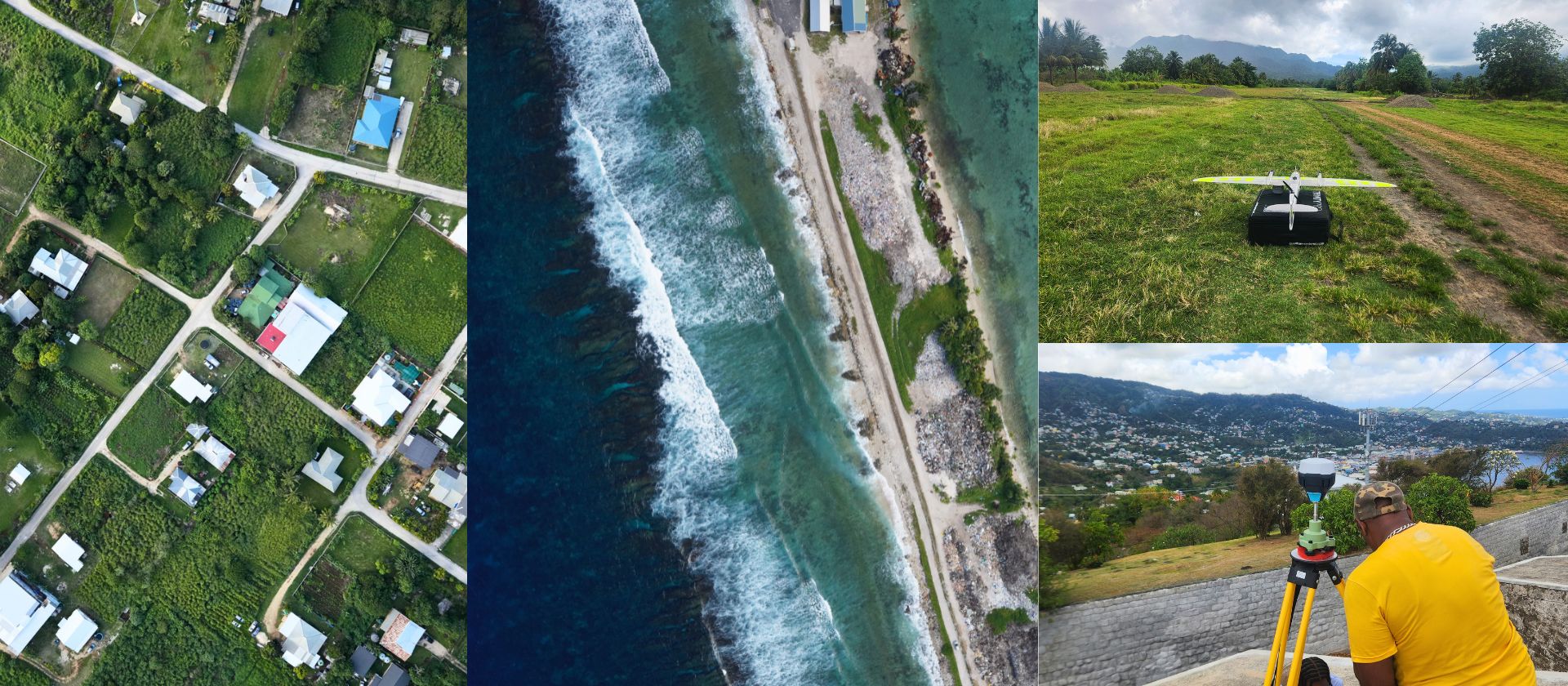
What we’ve seen on the ground
PLACE has worked with governments across the Pacific, Caribbean, and Atlantic, and the need is consistent: reliable, up-to-date geospatial data that can be used, maintained, and built on over time.
In Tuvalu, we mapped Funafuti’s streets and coastline, capturing over 1,000 aerial images to support sea-level rise modelling and solar potential analysis — basic planning tools for a nation whose land area is measured in square kilometres.
In Tonga, a 320 km² aerial survey and 800 km of street-level coverage is now forming the foundation for a national Digital Twin — a maintained, updatable data asset for national planning.
In St Vincent & the Grenadines, we replaced imagery that was more than two decades old. In Anguilla, new data enabled flood modelling and land-use classification that simply wasn’t possible before. In Turks & Caicos, consistent imagery has become a core tool for valuation, compliance, and coastal governance.
These projects matter because the data doesn’t disappear when we leave. It becomes part of how these governments work. You can explore more at thisisplace.org.
What comes next
At Geospatial World Forum 2026 (30 April, Amsterdam), the SIDS Seminar is focused on operationalising the SIDS Centre of Excellence and its Global Data Hub — a core outcome of the Antigua & Barbuda Agenda for SIDS.
This is a working session. Governments, multilateral partners, regional organisations, and private-sector teams will work through how this move from concept into implementation. The programme covers:
- SIDS Needs & Challenges — the vulnerabilities, development constraints, and climate pressures facing SIDS across the Caribbean, Pacific, and AIS regions.
- The SIDS Centre of Excellence & Global Data Hub — the integrated data ecosystem being deployed, combining curated datasets, cloud-based services, and national-level data hubs.
- Country Perspectives — insights from the first cohort of SIDS Country Data Hubs, including Tuvalu and Tonga, on how improved data access strengthens national planning.
- Partnerships for the Future — the private-sector and civil society partners supporting the CoE and Global Data Hub, and how collaboration accelerates delivery.
The goal is straightforward: to build the operational backbone for a shared data ecosystem that supports more informed planning and long-term resilience. Denise McKenzie, Managing Partner of PLACE, will be there as part of that work.
If you’d like to meet with Denise at GWF, please get in touch at [email protected].